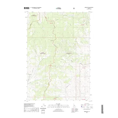
2020 Map of Wards Butte
USGS Topo · Published 2020About this map
Wards Butte stands as a prominent landmark within this high-elevation terrain, marking the divide between the Salmon National Forest and the Challis National Forest. This 2020 survey documents a complex network of drainage basins, where water moves from peaks like Iron Mountain into winding systems such as Big Hat Creek and Corral Creek-Hat Creek. The geography here is defined by its drainages and ridges rather than human settlements, with the county line between Lemhi and Custer counties threading through the northern reaches. Evidence of land management and access is visible through named routes like the Morgan Creek Rd and Hat Cr Rd, which provide passage through the steep terrain. Names like Sawmill Cr and Burnt Gulch suggest the area's history of local resource use and natural events within the forest boundaries.
Find a feature on this map
36 named features on this map. Tap any name to fly to it.
Don’t see what you’re looking for? This feature index may not catch every label — zoom into the map to look around manually.
Map Details
Editions of this 2020 Wards Butte Map
This is the sole edition of this map. No revisions or reprints were ever made.
Other maps of this area

1956 · Challis
USGS Topo · 1:62,500

1956 · Twin Peaks
USGS Topo · 1:62,500

1957 · Challis
USGS Topo · 1:250,000

1960 · Challis
USGS Topo · 1:250,000
1962 · Degan Mtn
USGS Topo · 1:24,000

1963 · Challis
USGS Topo · 1:250,000
1963 · Opal Lake
USGS Topo · 1:24,000
1963 · Black Mtn
USGS Topo · 1:24,000
1963 · Taylor Mountain
USGS Topo · 1:24,000
1963 · Hat Creek
USGS Topo · 1:24,000