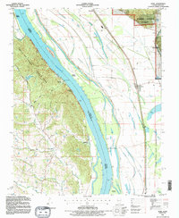
1993 Map of Ware
USGS Topo · Published 1996About this map
The Mississippi River creates a dramatic boundary between Illinois and Missouri, defining a landscape of wide floodplains and steep river bluffs. On the Missouri side, the rugged topography of Trail of Tears State Park rises above the water, hiding small settlements like Egypt Mills and its associated Egypt Mills Ch. This area is characterized by deep hollows drained by Flora Creek and Bainbridge Creek, leading down to historical river access points like Neelys Landing.
Find a feature on this map
35 named features on this map. Tap any name to fly to it.
Don’t see what you’re looking for? This feature index may not catch every label — zoom into the map to look around manually.
Map Details
Editions of this 1993 Ware Map
This is the sole edition of this map. No revisions or reprints were ever made.
Other maps of this area

1918 · Altenburg
USGS Topo · 1:62,500

1920 · Jonesboro
USGS Topo · 1:62,500

1922 · Cape Girardeau
USGS Topo · 1:62,500

1923 · Jonesboro
USGS Topo · 1:62,500

1924 · Cape Girardeau
USGS Topo · 1:62,500

1924 · Alto Pass
USGS Topo · 1:62,500

1925 · Altenburg
USGS Topo · 1:62,500

1947 · Jonesboro
USGS Topo · 1:62,500

1947 · Alto Pass
USGS Topo · 1:62,500

1947 · Mc Clure
USGS Topo · 1:24,000