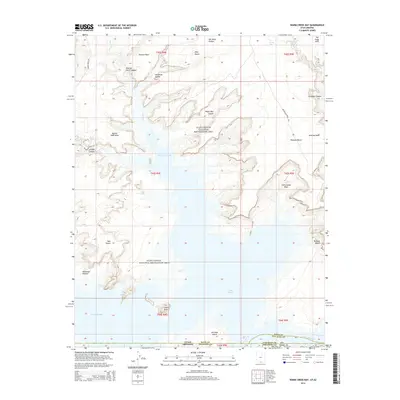
2014 Map of Warm Creek Bay
USGS Topo · Published 2014About this map
Warm Creek Bay and the submerged canyons of the Glen Canyon National Recreation Area dominate this 2014 survey. The map documents the intricate shoreline and high-desert terrain where the Utah-Arizona state line intersects the rising waters of Lake Powell. Significant landmarks like Castle Rock and Antelope Island rise above the basin, while the southern edge of the map follows the course of the Colorado River through Coconino County. This era is defined by the recreation-focused geography of the reservoir, reachable via Recreation Road 144 and Recreation Road 231. Topographical features such as Alstrom Point and the Wahweap Window illustrate the extreme verticality of the surrounding mesas and plateaus, including Romana Mesa and the Oley Knolls, providing a detailed look at the interface between the high desert and the modern reservoir system.
Find a feature on this map
39 named features on this map. Tap any name to fly to it.
Don’t see what you’re looking for? This feature index may not catch every label — zoom into the map to look around manually.
Map Details
Editions of this 2014 Warm Creek Bay Map
This is the sole edition of this map. No revisions or reprints were ever made.
Other maps of this area

1886 · Escalante
USGS Topo · 1:250,000

1886 · Echo Cliffs
USGS Topo · 1:250,000

1891 · Echo Cliffs
USGS Topo · 1:250,000

1922 · Warm Creek
USGS Topo · 1:63,360

1951 · Lees Ferry NE
USGS Topo · 1:24,000

1953 · Nipple Butte
USGS Topo · 1:62,500

1953 · Gunsight Butte
USGS Topo · 1:62,500

1954 · Leche-E Rock
USGS Topo · 1:62,500

1954 · Lees Ferry
USGS Topo · 1:62,500

1956 · Escalante
USGS Topo · 1:250,000