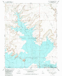
1985 Map of Warm Creek Bay
USGS Topo · Published 1985About this map
Lake Powell dominates the landscape of this 1985 survey, its waters reaching a Normal Pool Elevation 3700 and drowning the lower reaches of the many canyons that once fed the Colorado River. The topography is defined by the high plateaus and sheer drops of Alstrom Point and the Bull Points, which overlook the submerged basin. Within Glen Canyon National Recreation Area, various water-filled features like Warm Creek Bay and Wahweap Bay illustrate the dramatic transformation of the desert floor into a vast reservoir. Historical landmarks such as Castle Rock and Antelope Island rise above the waterline, while the upper reaches of Gunsight Canyon and Pasture Point Canyon remain largely terrestrial. A network of primitive routes, including a Jeep Trail and Pack Trail, trace the high ground above the flooded narrows, providing access to the remote terrain near the Navajo Indian Res.
Find a feature on this map
29 named features on this map. Tap any name to fly to it.
Don’t see what you’re looking for? This feature index may not catch every label — zoom into the map to look around manually.
Map Details
Editions of this 1985 Warm Creek Bay Map
This is the sole edition of this map. No revisions or reprints were ever made.
Other maps of this area

1886 · Escalante
USGS Topo · 1:250,000

1886 · Echo Cliffs
USGS Topo · 1:250,000

1891 · Echo Cliffs
USGS Topo · 1:250,000

1922 · Warm Creek
USGS Topo · 1:63,360

1951 · Lees Ferry NE
USGS Topo · 1:24,000

1953 · Nipple Butte
USGS Topo · 1:62,500

1953 · Gunsight Butte
USGS Topo · 1:62,500

1954 · Leche-E Rock
USGS Topo · 1:62,500

1954 · Lees Ferry
USGS Topo · 1:62,500

1956 · Escalante
USGS Topo · 1:250,000