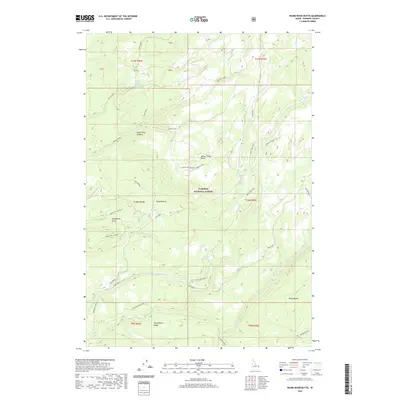
2020 Map of Warm River Butte
USGS Topo · Published 2020About this map
Island Park Caldera forms the dramatic geologic foundation of this northern Idaho landscape, where the high-altitude terrain of the Targhee National Forest transitions into a complex of volcanic buttes and ridges. Named landmarks such as Warm River Butte and Moose Creek Butte rise above a network of drainages including Robinson Cr and Moose Creek. The presence of the Warm River Lookout suggests the critical importance of fire observation across these heavily timbered slopes. Navigating the forest is made possible by a system of primitive routes like the Warm River Butte Rd and Moose Creek Butte Rd. For researchers, the map identifies numerous natural water sources essential for early travel and livestock, such as Horsefly Spring, Trail Canyon Spring, and Fish Creek Spring, alongside distinctive landforms like Twisted Draw and Huckleberry Ridge.
Find a feature on this map
40 named features on this map. Tap any name to fly to it.
Don’t see what you’re looking for? This feature index may not catch every label — zoom into the map to look around manually.
Map Details
Editions of this 2020 Warm River Butte Map
This is the sole edition of this map. No revisions or reprints were ever made.
Other maps of this area

1955 · Ashton
USGS Topo · 1:250,000

1957 · Warm River Butte
USGS Topo · 1:62,500

1957 · Buffalo Lake
USGS Topo · 1:62,500

1958 · Ashton
USGS Topo · 1:250,000

1960 · Ashton
USGS Topo · 1:250,000

1964 · Hatchery Butte
USGS Topo · 1:24,000

1965 · Snake River Butte
USGS Topo · 1:24,000
1965 · Warm River
USGS Topo · 1:24,000
1986 · Buffalo Lake
USGS Topo · 1:24,000
1986 · Big Grassy
USGS Topo · 1:24,000