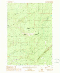
1989 Map of Warm River Butte
USGS Topo · Published 1989About this map
Targhee National Forest defines the character of this high-elevation Idaho landscape, where the drainage network of the Warm River Butte region is meticulously charted. The terrain is characterized by a complex system of waterways, including Moose Creek, Robinson Creek, and the North Fork Fish Creek, alongside numerous named springs such as Horsefly Spring and Bear Spring. The presence of Barrow Pit suggests localized resource extraction within the forest boundaries.
Find a feature on this map
27 named features on this map. Tap any name to fly to it.
Don’t see what you’re looking for? This feature index may not catch every label — zoom into the map to look around manually.
Map Details
Editions of this 1989 Warm River Butte Map
This is the sole edition of this map. No revisions or reprints were ever made.
Other maps of this area

1955 · Ashton
USGS Topo · 1:250,000

1957 · Warm River Butte
USGS Topo · 1:62,500

1957 · Buffalo Lake
USGS Topo · 1:62,500

1958 · Ashton
USGS Topo · 1:250,000

1960 · Ashton
USGS Topo · 1:250,000

1964 · Hatchery Butte
USGS Topo · 1:24,000

1965 · Snake River Butte
USGS Topo · 1:24,000
1965 · Warm River
USGS Topo · 1:24,000
1986 · Buffalo Lake
USGS Topo · 1:24,000
1986 · Big Grassy
USGS Topo · 1:24,000