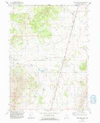
1991 Map of Warm Spring Hills
USGS Topo · Published 1992About this map
The Warm Spring Hills define this high-desert landscape in northern Utah, where intermittent water sources and ranching outposts dictate the pattern of human activity. This 1991 revision, based on aerial photography from the late 1960s and 1980s, captures the remote character of Box Elder County before the turn of the century. Notable for its network of springs and seasonal drainages, the map centers on the Muddy Ranch and a nearby Corral, indicating the area's continued reliance on livestock grazing. The drainage systems of Muddy Creek and Dove Creek are essential features for understanding the hydrology of this arid region. Several named water points like Rhus Spring and Seep Spring are critical landmarks for those tracing the history of land use and movement through these hills.
Find a feature on this map
11 named features on this map. Tap any name to fly to it.
Don’t see what you’re looking for? This feature index may not catch every label — zoom into the map to look around manually.
Map Details
Editions of this 1991 Warm Spring Hills Map
This is the sole edition of this map. No revisions or reprints were ever made.
Other maps of this area

1954 · Brigham City
USGS Topo · 1:250,000

1958 · Brigham City
USGS Topo · 1:250,000

1959 · Park Valley
USGS Topo · 1:62,500

1959 · Yost
USGS Topo · 1:62,500

1962 · Brigham City
USGS Topo · 1:250,000

1971 · Prohibition Spring
USGS Topo · 1:24,000

1971 · Emigrant Pass
USGS Topo · 1:24,000

1971 · Potters Creek
USGS Topo · 1:24,000

1971 · Red Dome
USGS Topo · 1:24,000
1971 · Runswick Wash
USGS Topo · 1:24,000