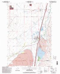
1996 Map of Warm Springs
USGS Topo · Published 1998About this map
The Montana State Hospital Warm Springs Campus and the Montana State Hospital Galen Campus anchor this 1990s landscape, illustrating the region's specialized role in institutional care and mental health services in Montana. The settlement of Warm Springs is depicted in detail, showing the Post Office and a local Cemetery alongside the Hot Spring that gave the area its name.
Find a feature on this map
33 named features on this map. Tap any name to fly to it.
Don’t see what you’re looking for? This feature index may not catch every label — zoom into the map to look around manually.
Map Details
Editions of this 1996 Warm Springs Map
This is the sole edition of this map. No revisions or reprints were ever made.
Other maps of this area

1889 · Helena
USGS Topo · 1:250,000

1893 · Helena
USGS Topo · 1:250,000

1899 · Helena
USGS Topo · 1:250,000

1903 · Helena
USGS Topo · 1:250,000

1947 · Butte
USGS Topo · 1:250,000

1958 · Butte
USGS Topo · 1:250,000

1959 · Butte North
USGS Topo · 1:62,500

1959 · Deer Lodge
USGS Topo · 1:62,500

1960 · Butte
USGS Topo · 1:250,000

1961 · Anaconda
USGS Topo · 1:62,500