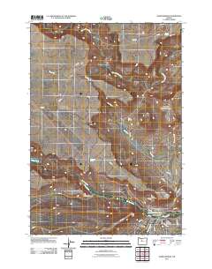
2011 Map of Warm Springs
USGS Topo · Published 2011About this map
Warm Springs serves as the focal point of this 2011 survey, situated at the confluence of several vital watercourses and road systems. The map illustrates the administrative and communal hub of the area, featuring the Warm Springs Agency Office and the Warm Springs Post Office near the banks of Shitike Creek. Residential developments such as Miller Heights and Elliot Heights sit east of the central town, while the surrounding geography is defined by prominent landforms like Klawhop Butte to the north and the distinct West Hills.
Find a feature on this map
41 named features on this map. Tap any name to fly to it.
Don’t see what you’re looking for? This feature index may not catch every label — zoom into the map to look around manually.
Map Details
Editions of this 2011 Warm Springs Map
This is the sole edition of this map. No revisions or reprints were ever made.
Other maps of this area

1928 · Madras
USGS Topo · 1:125,000

1931 · Madras
USGS Topo · 1:125,000

1955 · Bend
USGS Topo · 1:250,000

1957 · Bend
USGS Topo · 1:250,000

1958 · Bend
USGS Topo · 1:250,000

1962 · Metolius Bench
USGS Topo · 1:24,000
1962 · Simnasho
USGS Topo · 1:24,000
1962 · Hehe Butte
USGS Topo · 1:24,000

1962 · Eagle Butte
USGS Topo · 1:24,000
1962 · Seekseequa Junction
USGS Topo · 1:24,000