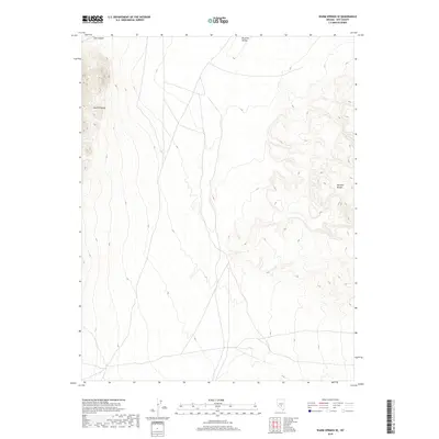
2018 Map of Warm Springs SE
USGS Topo · Published 2018About this map
Reveille Valley forms a broad, arid corridor between two prominent Great Basin uplands in this modern 2018 survey. The eastern portion of the map is dominated by the steep escarpments of the Reveille Range, while the western edge captures the rising slopes of the Kawich Range. This high-desert landscape is defined by its drainage patterns and vertical relief rather than human settlement, reflecting a remote corner of Nye County. The terrain transitions from the alluvial floor of the valley toward the rugged topography of Cow Canyon in the northwest. This topographical study provides a detailed view of the Public Land Survey System boundaries, specifically the intersections of t3n r50e, t3n r51e, t2n r50e, and t2n r51e, which are essential for locating specific land parcels and historical mining claims in this desert region.
Find a feature on this map
8 named features on this map. Tap any name to fly to it.
Don’t see what you’re looking for? This feature index may not catch every label — zoom into the map to look around manually.
Map Details
Editions of this 2018 Warm Springs SE Map
This is the sole edition of this map. No revisions or reprints were ever made.
Other maps of this area

1908 · Kawich
USGS Topo · 1:250,000

1942 · Reveille Peak
USGS Topo · 1:125,000

1952 · Kawich Peak
USGS Topo · 1:62,500

1952 · Reveille Peak
USGS Topo · 1:62,500

1954 · Goldfield
USGS Topo · 1:250,000

1955 · Goldfield
USGS Topo · 1:250,000

1956 · Tonopah
USGS Topo · 1:250,000

1958 · Goldfield
USGS Topo · 1:250,000

1959 · Tonopah
USGS Topo · 1:250,000

1962 · Goldfield
USGS Topo · 1:250,000