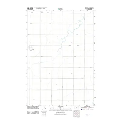
2012 Map of Warner
USGS Topo · Published 2012About this map
The town of Warner serves as the focal point of this Brown County landscape, situated along the western edge of the quadrangle. A structured grid of residential streets, including E Main St and 4th St Se, defines the settlement area, while the surrounding territory is primarily organized by a rigid section-line road network of avenues and streets. The winding course of Moccasin Cr meanders through the central and northern portions of the map, eventually leading toward the James River at the eastern boundary. This drainage pattern highlights the subtle topography of the Glacial Lake Dakota bed. Local aviation history is represented by Thorson Airfield located to the north, which together with the surrounding farm-to-market roads like 387th Ave, illustrates the modern rural infrastructure of the early 21st century.
Find a feature on this map
22 named features on this map. Tap any name to fly to it.
Don’t see what you’re looking for? This feature index may not catch every label — zoom into the map to look around manually.
Map Details
Editions of this 2012 Warner Map
This is the sole edition of this map. No revisions or reprints were ever made.
Other maps of this area

1895 · Aberdeen
USGS Topo · 1:125,000

1899 · Northville
USGS Topo · 1:125,000

1953 · Brentford
USGS Topo · 1:24,000

1953 · Stratford
USGS Topo · 1:24,000

1953 · Warner
USGS Topo · 1:24,000

1954 · Bath
USGS Topo · 1:24,000

1954 · Mellette
USGS Topo · 1:24,000

1954 · Aberdeen
USGS Topo · 1:250,000

1956 · Aberdeen
USGS Topo · 1:250,000
1960 · Aberdeen East
USGS Topo · 1:24,000