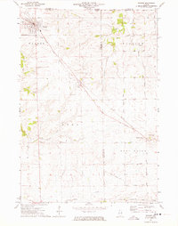
1971 Map of Warren
USGS Topo · Published 1974About this map
The Illinois Central Gulf railroad serves as the spine of this Jo Daviess County landscape, cutting diagonally through the settlements of Warren, Nora, and Waddams Grove. This 1971 survey captures the region's agricultural and rural infrastructure at the start of the decade, featuring a dense network of country roads like West Galena Road and North Waddams Grove Road. Genealogy researchers will find several well-defined burial sites across the township lines, including St Anns Cem near Warren, the West Chelsea Cem and East Chelsea Cem pair, and the isolated Holly Grove Cem near Howardsville. The terrain is characterized by the winding Apple River and its South Fork, alongside smaller watercourses like Wolf Creek and Yellow Creek. Distinctive local landmarks such as the Fairground and Sewage Disposal in Warren, the Withn Landing Strip, and numerous active Quarries illustrate the local economy and land use during this era.
Find a feature on this map
47 named features on this map. Tap any name to fly to it.
Don’t see what you’re looking for? This feature index may not catch every label — zoom into the map to look around manually.
Map Details
Editions of this 1971 Warren Map
This is the sole edition of this map. No revisions or reprints were ever made.
Other maps of this area

1902 · Mineral Point
USGS Topo · 1:125,000

1911 · Elizabeth
USGS Topo · 1:62,500

1923 · South Wayne
USGS Topo · 1:62,500

1936 · Elizabeth
USGS Topo · 1:62,500

1937 · Lena
USGS Topo · 1:48,000

1942 · Lena
USGS Topo · 1:62,500

1943 · Lena
USGS Topo · 1:62,500

1954 · Rockford
USGS Topo · 1:250,000

1955 · Rockford
USGS Topo · 1:250,000

1958 · Rockford
USGS Topo · 1:250,000