
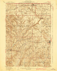
1911 Map of Elizabeth
USGS Topo · Published 1911About this map
Elizabeth stands as a central hub in Jo Daviess County at the height of the driftless area's mining and agricultural activity. The landscape is marked by a dense network of country schools, such as Equal Rights School and Terrapin Ridge School, serving a rural population before the consolidation of the mid-20th century. Lead and zinc mining legacies are clearly visible through labels for the Wishon Mine, Hagerty Mine, and Skene Mine southwest of town. Three major rail lines, including the Illinois Central RR and Chicago Great Western RR, cut through the ridges and valleys, connecting settlements like Scales Mound and Stockton to regional markets. The map captures the intricate drainage of the Apple River and its numerous forks, which dictated the placement of early roads and the small hamlets of Schapville and Millyville.
Find a feature on this map
94 named features on this map. Tap any name to fly to it.
Don’t see what you’re looking for? This feature index may not catch every label — zoom into the map to look around manually.
Map Details
Editions of this 1911 Elizabeth Map
2 editions found
Other maps of this area

1892 · Savanna
USGS Topo · 1:62,500

1902 · Mineral Point
USGS Topo · 1:125,000

1911 · Galena
USGS Topo · 1:62,500

1913 · Galena
USGS Topo · 1:62,500

1923 · South Wayne
USGS Topo · 1:62,500

1935 · Miles
USGS Topo · 1:62,500

1936 · Elizabeth
USGS Topo · 1:62,500

1937 · Lena
USGS Topo · 1:48,000

1941 · Miles
USGS Topo · 1:62,500

1942 · Mt Carroll
USGS Topo · 1:62,500