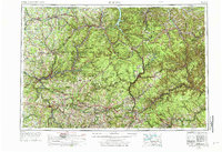
1957 Map of Warren
USGS Topo · Published 1976About this map
The Allegheny Mountains dominate this 1957 survey area, revealing a landscape defined by deep river valleys and massive tracts of protected woodland. Significant infrastructure projects of the mid-20th century are evident, most notably the Kinzua Dam on the Allegheny River and the East Branch Clarion River Dam, which altered the hydrology of the northern plateau. The region's industrial backbone is visible through a dense network of rail lines including the Pennsylvania RR, Erie RR, and the Baltimore & Ohio RR which served the manufacturing and timber hubs of Warren, Bradford, and Oil City. Extensive public lands, from the Allegheny National Forest to the Moshannon State Forest, illustrate the massive reforestation efforts and conservation boundaries established across north-central Pennsylvania and the southern tier of New York.
Find a feature on this map
54 named features on this map. Tap any name to fly to it.
Don’t see what you’re looking for? This feature index may not catch every label — zoom into the map to look around manually.
Map Details
Editions of this 1957 Warren Map
4 editions found

Other maps of this area

1898 · Olean
USGS Topo · 1:62,500

1899 · Erie
USGS Topo · 1:62,500

1900 · Erie
USGS Topo · 1:62,500

1900 · Salamanca
USGS Topo · 1:62,500

1900 · Kittanning
USGS Topo · 1:62,500

1901 · Rural Valley
USGS Topo · 1:62,500

1902 · Kittanning
USGS Topo · 1:62,500

1903 · Curwensville
USGS Topo · 1:62,500

1903 · Rural Valley
USGS Topo · 1:62,500

1903 · Houtzdale
USGS Topo · 1:62,500