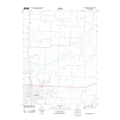
2011 Map of Warrensburg East
USGS Topo · Published 2011About this map
The University of Central Missouri anchor the southwestern portion of this 2011 survey, where the expanding street grid of Warrensburg meets the agricultural landscapes of Johnson County. This area is defined by a dense network of country roads, such as NE State Hwy E and NE 600th Rd, which navigate a complex drainage system led by the Blackwater River. The river's meandering course is joined by numerous tributaries including Bear Creek, Post Oak Creek, and Blackjack Creek, creating a landscape of gentle relief and riparian corridors. Scattered throughout these rural sections are several smaller burial grounds, such as Liberty Cemetery and Granger Cemetery, which serve as vital touchstones for local family histories. The transition from the academic and municipal center of Warrensburg to the outlying farmsteads is marked by the presence of family-named landmarks like Maxwell Cemetery and Mayes Cemetery.
Find a feature on this map
83 named features on this map. Tap any name to fly to it.
Don’t see what you’re looking for? This feature index may not catch every label — zoom into the map to look around manually.
Map Details
Editions of this 2011 Warrensburg East Map
This is the sole edition of this map. No revisions or reprints were ever made.
Other maps of this area

1885 · Warrensburg
USGS Topo · 1:125,000

1887 · Warrensburg
USGS Topo · 1:125,000

1894 · Warrensburg
USGS Topo · 1:125,000

1917 · Knobnoster
USGS Topo · 1:62,500

1947 · Jefferson City
USGS Topo · 1:250,000

1954 · Jefferson City
USGS Topo · 1:250,000

1954 · Centerview
USGS Topo · 1:24,000

1955 · Cornelia
USGS Topo · 1:24,000
1955 · Burtville
USGS Topo · 1:24,000

1955 · Jefferson City
USGS Topo · 1:250,000