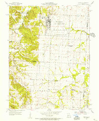
1955 Map of Burtville
USGS Topo · Published 1956About this map
Whiteman Air Force Base dominates the eastern plateau of this Missouri landscape, showcasing its extensive runways and facility layout during the mid-1950s. To the west, the terrain transitions into the creek-carved hills of Knob Noster State Park, where recreation sites like Camp Red Cedar and Camp Bobwhite are situated among water bodies such as Lake Buteo and Shawnee Pond. This period captures a shift in rural education, with several one-room schoolhouses labeled as abandoned, including Brushy Sch and Prairie Home Sch. The local economy is represented by a Strip Mine in the southern reaches and agricultural settlements like Burtville and Owsley. Waterways including the Clear Fork and Muddy Creek define the drainage patterns, while family-named landmarks such as Ellis Cem and Pleasant Hill Ch provide essential points of reference for genealogical research in Johnson and Pettis counties.
Find a feature on this map
42 named features on this map. Tap any name to fly to it.
Don’t see what you’re looking for? This feature index may not catch every label — zoom into the map to look around manually.
Map Details
Editions of this 1955 Burtville Map
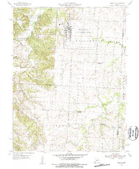
2 editions found
Other maps of this area

1885 · Warrensburg
USGS Topo · 1:125,000

1887 · Sedalia
USGS Topo · 1:125,000

1887 · Warrensburg
USGS Topo · 1:125,000

1894 · Sedalia
USGS Topo · 1:125,000

1894 · Warrensburg
USGS Topo · 1:125,000

1917 · Knobnoster
USGS Topo · 1:62,500

1939 · Sweet Springs
USGS Topo · 1:62,500

1940 · Sweet Springs
USGS Topo · 1:62,500

1941 · Sweet Springs
USGS Topo · 1:62,500

1945 · Sweet Springs
USGS Topo · 1:62,500