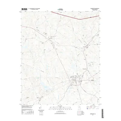
2017 Map of Warrenton
USGS Topo · Published 2017About this map
Warrenton serves as the focal point of this Warren County landscape, showing the town's modern footprint alongside the established settlements of Norwood, Camak, and Silvertown. The map is particularly rich for genealogical research, documenting dozens of burial sites including the Scott and Labor Home Society Cem, Gospel Aid Society Cem, and Union Star Cem. These named cemeteries, often tied to specific families or local societies, are scattered across the terrain between Rocky Comfort Cr and Middle Cr. Industrial and utility features like Aggregates Lake and the Warrenton City Pond reflect the county's management of water resources and mineral extraction. The small community of Norris appears in the southern portion of the sheet, connected by local routes like Old Greensboro Rd that bridge the gaps between rural farmsteads and these central townships.
Find a feature on this map
115 named features on this map. Tap any name to fly to it.
Don’t see what you’re looking for? This feature index may not catch every label — zoom into the map to look around manually.
Map Details
Editions of this 2017 Warrenton Map
This is the sole edition of this map. No revisions or reprints were ever made.
Other maps of this area

1906 · Crawfordville
USGS Topo · 1:125,000

1953 · Athens
USGS Topo · 1:250,000

1958 · Athens
USGS Topo · 1:250,000

1959 · Athens
USGS Topo · 1:250,000

1963 · Athens
USGS Topo · 1:250,000

1971 · Beall Springs
USGS Topo · 1:24,000
1972 · Wrightsboro
USGS Topo · 1:24,000
1972 · Bastonville
USGS Topo · 1:24,000
1972 · Thomson West
USGS Topo · 1:24,000

1972 · Sharon
USGS Topo · 1:24,000