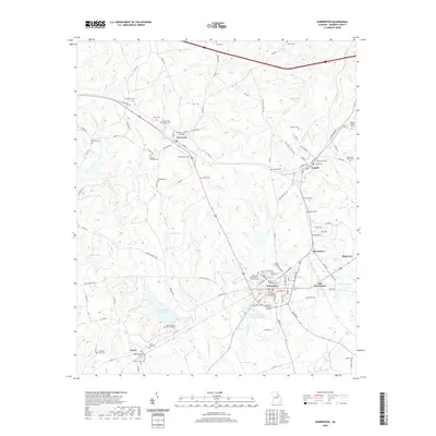
2020 Map of Warrenton
USGS Topo · Published 2020About this map
Warrenton serves as the seat of local government and the primary hub for Warren County, with the historic Warren County Courthouse anchoring the town center. The landscape is defined by the headwaters of Rocky Comfort Cr and Goldens Cr, which drain a rolling Piedmont terrain characterized by small family settlements and numerous legacy burial grounds. To the west, the village of Norwood sits at a crossroads of ancient routes like Old Greensboro Rd, while Camak and its associated Camak Cem mark the railroad-oriented corridors to the northeast. Genealogists will find this sheet particularly valuable for its precise documentation of family-named landmarks and societal plots, including the Gospel Aid Society Cem, the Jane Hampton Ball Gravesite, and the Thomas Gibson Cem. The map illustrates the contemporary balance between historic land use and newer water management features like Reservoir 14 and Nelson Lake.
Find a feature on this map
115 named features on this map. Tap any name to fly to it.
Don’t see what you’re looking for? This feature index may not catch every label — zoom into the map to look around manually.
Map Details
Editions of this 2020 Warrenton Map
This is the sole edition of this map. No revisions or reprints were ever made.
Other maps of this area

1906 · Crawfordville
USGS Topo · 1:125,000

1953 · Athens
USGS Topo · 1:250,000

1958 · Athens
USGS Topo · 1:250,000

1959 · Athens
USGS Topo · 1:250,000

1963 · Athens
USGS Topo · 1:250,000

1971 · Beall Springs
USGS Topo · 1:24,000
1972 · Wrightsboro
USGS Topo · 1:24,000
1972 · Bastonville
USGS Topo · 1:24,000
1972 · Thomson West
USGS Topo · 1:24,000

1972 · Sharon
USGS Topo · 1:24,000