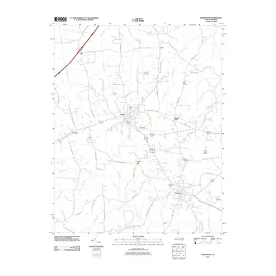
2010 Map of Warrenton
USGS Topo · Published 2010About this map
Warrenton and Norlina anchor this northern North Carolina landscape, where a dense network of country roads connects historic family settlements and community landmarks. The topography is defined by the headwaters of numerous waterways, including Fishing Creek and Possumquarter Creek, which carve through the terrain south of the Warren County Airport. Local history is preserved in several burial grounds such as the Old Warrenton Cemetery and Warren Dale Cemetery, while smaller rural clusters like Wise, Oine, and Ridgeway reflect the area’s longstanding agricultural character. Named roads like Old Reavis Mill Rd and Michaels Quarry Rd hint at the former rural industries that once dotted the banks of Terrapin Creek and Malones Creek, and the presence of Camp Katzenstein in the southeast corner provides a contemporary point of interest in this predominantly traditional rural setting.
Find a feature on this map
74 named features on this map. Tap any name to fly to it.
Don’t see what you’re looking for? This feature index may not catch every label — zoom into the map to look around manually.
Map Details
Editions of this 2010 Warrenton Map
This is the sole edition of this map. No revisions or reprints were ever made.
Other maps of this area

1953 · Greensboro
USGS Topo · 1:250,000

1954 · Greensboro
USGS Topo · 1:250,000

1955 · Boydton
USGS Topo · 1:62,500

1962 · Greensboro
USGS Topo · 1:250,000

1966 · Greensboro
USGS Topo · 1:250,000

1968 · South Hill SE
USGS Topo · 1:24,000

1968 · Bracey
USGS Topo · 1:24,000

1968 · John H Kerr Dam
USGS Topo · 1:24,000
1970 · Macon
USGS Topo · 1:24,000

1970 · Vicksboro
USGS Topo · 1:24,000