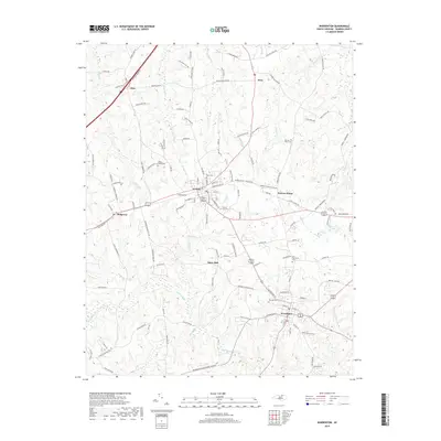
2019 Map of Warrenton
USGS Topo · Published 2019About this map
Warrenton and Norlina anchor this survey of central Warren County, where the landscape is defined by the headwaters of numerous creeks draining toward the Piedmont's rolling divide. The drainage network is particularly dense here, featuring the branching stems of Fishing Cr, Horse Cr, and Possomquarter Cr. This 2019 data reveals how local roads like Old Reavis Mill Rd and Wise Five Forks Rd follow the high ground between these watercourses, maintaining a settlement pattern that connects established communities like Warren Plains and Ridgeway. For the genealogist or local historian, the map identifies critical burial sites across the township, including the Old Warrenton Cem, Fairview Cem, and the more rural Whites Grove Cem. The proximity of settlements like Snow Hill and Wise to the branching paths of Reedy Br and Cabin Br illustrates the enduring relationship between the area's geography and its historical development.
Find a feature on this map
127 named features on this map. Tap any name to fly to it.
Don’t see what you’re looking for? This feature index may not catch every label — zoom into the map to look around manually.
Map Details
Editions of this 2019 Warrenton Map
This is the sole edition of this map. No revisions or reprints were ever made.
Other maps of this area

1953 · Greensboro
USGS Topo · 1:250,000

1954 · Greensboro
USGS Topo · 1:250,000

1955 · Boydton
USGS Topo · 1:62,500

1962 · Greensboro
USGS Topo · 1:250,000

1966 · Greensboro
USGS Topo · 1:250,000

1968 · South Hill SE
USGS Topo · 1:24,000

1968 · Bracey
USGS Topo · 1:24,000

1968 · John H Kerr Dam
USGS Topo · 1:24,000
1970 · Macon
USGS Topo · 1:24,000

1970 · Vicksboro
USGS Topo · 1:24,000