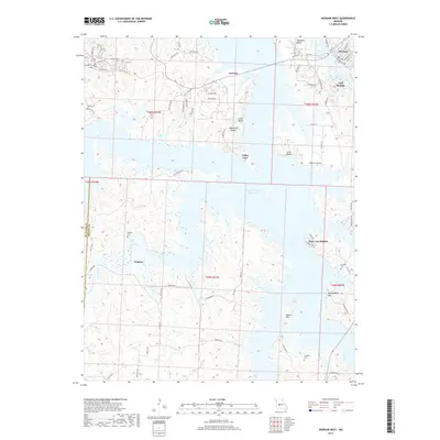
2017 Map of Warsaw West
USGS Topo · Published 2017About this map
The Harry S Truman Reservoir and Lake of the Ozarks dominate the landscape of Benton County, Missouri, where complex finger-like inlets carve into the surrounding hills. On the eastern shore, the settlement of Warsaw sits at a geographic crossroads, while small communities like Wisdom and Cold Springs are found along the winding ridges. The topography is defined by high points such as Indian Hill and Mockingbird Hill, and dramatic overlooks at Cobb Bluff and Laird Bluff. Local history is preserved in small family and community burial grounds, including Wisdom Cem, Crabtree Cem, and Campbell Cem. The road network, including State Hwy 7 and State Hwy K, snakes through the valleys and over the plateaus, connecting residential areas like Pom-o-sa Heights and Valley View to the larger waterways. This survey reflects the modern interplay between recreational reservoir geography and established rural settlements.
Find a feature on this map
83 named features on this map. Tap any name to fly to it.
Don’t see what you’re looking for? This feature index may not catch every label — zoom into the map to look around manually.
Map Details
Editions of this 2017 Warsaw West Map
This is the sole edition of this map. No revisions or reprints were ever made.
Other maps of this area

1887 · Clinton
USGS Topo · 1:125,000

1887 · Warsaw
USGS Topo · 1:125,000

1894 · Warsaw
USGS Topo · 1:125,000

1894 · Clinton
USGS Topo · 1:125,000

1935 · Dell
USGS Topo · 1:24,000

1936 · Shawnee Bend
USGS Topo · 1:24,000

1936 · Schuyler
USGS Topo · 1:24,000

1940 · Iconium
USGS Topo · 1:24,000

1941 · Valhalla
USGS Topo · 1:24,000
1944 · Iconium
USGS Topo · 1:24,000