
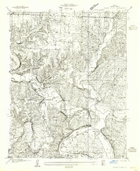
1936 Map of Schuyler
USGS Topo · Published 1936About this map
The newly created Lake Of The Ozarks dominates the southern reaches of this Benton County landscape, where the waters of the Turkey Creek Arm wind through narrow valleys and hollows. Surveyed in the mid-1930s, the map reveals a rural society transitioning alongside the massive reservoir project, with recreation points like Jacksons Beach and Bel-Moir Camp appearing along the shoreline. Further inland, the settlement patterns of White and Williams townships remain deeply rooted in traditional agriculture and community centers. The map preserves the exact locations of numerous country schools, including McFarland School, Poplar School, and Allen School, which served the scattered farmsteads. Transportation is anchored by the Missouri Pacific railroad and the Missouri Pacific No 65 Highway, which cut through the western terrain near the village of Schuyler. Local history is meticulously recorded through sites such as Pleasant Hill Church and the Feaster Cem.
Find a feature on this map
32 named features on this map. Tap any name to fly to it.
Don’t see what you’re looking for? This feature index may not catch every label — zoom into the map to look around manually.
Map Details
Editions of this 1936 Schuyler Map
This is the sole edition of this map. No revisions or reprints were ever made.
Other maps of this area

1887 · Warsaw
USGS Topo · 1:125,000

1894 · Warsaw
USGS Topo · 1:125,000

1935 · Edwards
USGS Topo · 1:24,000

1935 · Dell
USGS Topo · 1:24,000

1936 · Shawnee Bend
USGS Topo · 1:24,000

1936 · Lakeview Heights
USGS Topo · 1:24,000

1945 · Fristoe
USGS Topo · 1:62,500

1947 · Jefferson City
USGS Topo · 1:250,000

1954 · Jefferson City
USGS Topo · 1:250,000
1955 · Shawnee Bend
USGS Topo · 1:24,000