
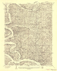
1936 Map of Lakeview Heights
USGS Topo · Published 1936About this map
The Lake of the Ozarks shoreline dominates the southern landscape of this mid-1930s survey, showing the complex inlets and points created by the damming of the Osage River. Development along the water is evident in early recreational and residential footprints such as Lakeview Heights, Lakeside Estates, and Hodges Camp. Further inland, the map reveals a rural Ozark community structured around a network of country schools and churches. Educational landmarks including Lutjen School, Ross School, and Byler School are scattered across the winding ridges and deep hollows like Byler Hollow. The presence of established burial grounds such as Mossy Cem and Brushy Cem, alongside the Mount Hulda Ch, provides essential data for genealogists tracing family roots in Benton County during the post-Depression era. The terrain is defined by dramatic relief, with the Cole Camp Creek Arm cutting deep into the northern reaches of the reservoir's fingers.
Find a feature on this map
28 named features on this map. Tap any name to fly to it.
Don’t see what you’re looking for? This feature index may not catch every label — zoom into the map to look around manually.
Map Details
Editions of this 1936 Lakeview Heights Map
2 editions found
Other maps of this area

1887 · Warsaw
USGS Topo · 1:125,000

1894 · Warsaw
USGS Topo · 1:125,000

1935 · Edwards
USGS Topo · 1:24,000

1935 · Dell
USGS Topo · 1:24,000

1935 · Boylers Mill
USGS Topo · 1:24,000

1935 · Knobby Creek
USGS Topo · 1:24,000

1936 · Schuyler
USGS Topo · 1:24,000

1945 · Fristoe
USGS Topo · 1:62,500

1947 · Jefferson City
USGS Topo · 1:250,000

1954 · Jefferson City
USGS Topo · 1:250,000