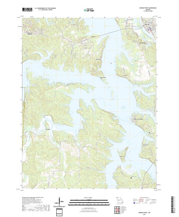
2021 Map of Warsaw West
USGS Topo · Published 2021About this map
The Benton County Courthouse in Warsaw serves as the focal point for this section of Missouri, where the sprawling fingers of the Harry S Truman Reservoir dominate the landscape. This 2021 survey shows a complex geography shaped by massive water management, where the reservoir meets the northern edge of the Lake of the Ozarks. Between these major water bodies, smaller settlements such as Wisdom, Tackner, and Cold Springs are connected by a network of state highways and local routes like State Hwy Z and State Hwy KK. Genealogists can find several historic burial sites, including Wisdom Cem, Crabtree Cem, and Campbell Cem, which remain as markers of the area's rural heritage amidst modern recreational developments like Bent Tree Harbor and Pom-o-sa Heights. Elevation markers such as Cobb Bluff and Indian Hill provide a look at the natural relief that defined the region before the valleys were partially submerged.
Find a feature on this map
70 named features on this map. Tap any name to fly to it.
Don’t see what you’re looking for? This feature index may not catch every label — zoom into the map to look around manually.
Map Details
Editions of this 2021 Warsaw West Map
This is the sole edition of this map. No revisions or reprints were ever made.
Other maps of this area

1887 · Clinton
USGS Topo · 1:125,000

1887 · Warsaw
USGS Topo · 1:125,000

1894 · Warsaw
USGS Topo · 1:125,000

1894 · Clinton
USGS Topo · 1:125,000

1935 · Dell
USGS Topo · 1:24,000

1936 · Shawnee Bend
USGS Topo · 1:24,000

1936 · Schuyler
USGS Topo · 1:24,000

1940 · Iconium
USGS Topo · 1:24,000

1941 · Valhalla
USGS Topo · 1:24,000
1944 · Iconium
USGS Topo · 1:24,000