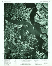
1980 Map of Warsaw West
USGS Topo · Published 1982About this map
The expansive waters of the Harry S Truman Reservoir dominate this 1980 orthophotomap, showing the dramatic transformation of the Benton County landscape. This aerial-based survey captures the intricate, drowned shoreline of the Osage River valley, where the reservoir’s rising fingers reach toward the established town of Warsaw in the northeast. Small residential developments and traditional settlements are caught in this moment of transition, with Valley View and Pom-O-Sa Heights positioned along the new waterfront. Farther from the main reservoir body, the upland areas around Wisdom and Tackner retain their rural character, revealed through the sharp photographic detail of woodlots and local roads. The contrast between the dark, still reservoir and the high-relief terrain of the Missouri Ozarks provides a clear record of the region’s mid-century hydrological engineering and subsequent land-use shifts.
Find a feature on this map
9 named features on this map. Tap any name to fly to it.
Don’t see what you’re looking for? This feature index may not catch every label — zoom into the map to look around manually.
Map Details
Editions of this 1980 Warsaw West Map
This is the sole edition of this map. No revisions or reprints were ever made.
Other maps of this area

1887 · Clinton
USGS Topo · 1:125,000

1887 · Warsaw
USGS Topo · 1:125,000

1894 · Warsaw
USGS Topo · 1:125,000

1894 · Clinton
USGS Topo · 1:125,000

1935 · Dell
USGS Topo · 1:24,000

1936 · Shawnee Bend
USGS Topo · 1:24,000

1936 · Schuyler
USGS Topo · 1:24,000

1940 · Iconium
USGS Topo · 1:24,000

1941 · Valhalla
USGS Topo · 1:24,000
1944 · Iconium
USGS Topo · 1:24,000