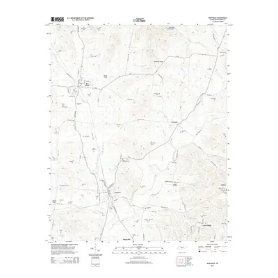
2014 Map of Wartrace
USGS Topo · Published 2014About this map
Bell Buckle and Wartrace anchor this Bedford County landscape, where historical town centers meet the winding drainages of the Central Basin. The area is defined by a dense network of family and community burial grounds, including the Old Salem Cem, Norvell Cem, and Beachboard Cem, which provide significant data points for genealogical research in middle Tennessee. The topography is shaped by the Garrison Fork and numerous small branches like Hoover Br and Kelly Cr that carve out named geographic features such as Happy Valley and Blackman Hollow. Small settlements and rural crossroads like Fairfield, Bugscuffle, and Union Ridge illustrate the enduring pattern of local community nodes. The mapping detail shows the convergence of rail and road infrastructure, particularly around the railway corridor at Wartrace, which historically served as a vital transportation hub for the surrounding agricultural district.
Find a feature on this map
133 named features on this map. Tap any name to fly to it.
Don’t see what you’re looking for? This feature index may not catch every label — zoom into the map to look around manually.
Map Details
Editions of this 2014 Wartrace Map
This is the sole edition of this map. No revisions or reprints were ever made.
Other maps of this area

1913 · Hollow Springs
USGS Topo · 1:62,500

1936 · Ovoca
USGS Topo · 1:24,000

1936 · Webbs Jungle
USGS Topo · 1:24,000

1936 · Shelbyville
USGS Topo · 1:24,000

1936 · Deason
USGS Topo · 1:24,000

1936 · Beech Grove
USGS Topo · 1:24,000

1936 · Noah
USGS Topo · 1:24,000

1936 · Wartrace
USGS Topo · 1:24,000

1936 · Normandy
USGS Topo · 1:24,000

1936 · Fosterville
USGS Topo · 1:24,000