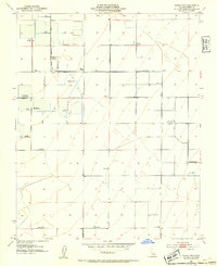
1953 Map of Wasco NW
USGS Topo · Published 1954About this map
Sportsman's clubs and irrigation infrastructure dominate this landscape in the southern San Joaquin Valley. The Alpaugh Irrigation District Canal defines the western agricultural boundary, while a high concentration of private hunting grounds such as the 20th Century Fish & Gun Club, Lurline Gun Club, and Pazuza Gun Club suggest a region historically managed for waterfowl and recreation. The terrain is notably flat, marked by a systematic grid of roads like Wildwood Road and Elmo Highway, and supported by utilities such as the Smyrna Substation. Numerous water features, including Lurline Wells and various scattered reservoirs, underscore the intensive water management required for this arid ranching and farming district, which the USGS notes as lying within a subsidence area.
Find a feature on this map
35 named features on this map. Tap any name to fly to it.
Don’t see what you’re looking for? This feature index may not catch every label — zoom into the map to look around manually.
Map Details
Editions of this 1953 Wasco NW Map
Other maps of this area

1914 · Lost Hills
USGS Topo · 1:125,000

1927 · Semitropic
USGS Topo · 1:31,680

1929 · Hacienda Ranch
USGS Topo · 1:31,680

1929 · Stone
USGS Topo · 1:31,680

1929 · Allensworth
USGS Topo · 1:31,680

1930 · Leonards
USGS Topo · 1:31,680

1930 · Hamlin School
USGS Topo · 1:31,680

1930 · Wasco
USGS Topo · 1:31,680

1930 · Pond
USGS Topo · 1:31,680

1930 · Miramonte Ranch
USGS Topo · 1:31,680