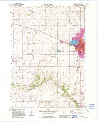
1991 Map of Waseca
USGS Topo · Published 1995About this map
The city of Waseca serves as the focal point of this landscape, situated alongside Loon Lake where the Chicago and North Western railroad bisects the town. This area of south-central Minnesota shows a well-defined transition from urban development to an agricultural and managed wilderness perimeter. To the south, the Le Sueur River meanders through the townships of Wilton and Otisco, passing near several rural burial grounds including Wilton Cem and Calvary Cem.
Find a feature on this map
36 named features on this map. Tap any name to fly to it.
Don’t see what you’re looking for? This feature index may not catch every label — zoom into the map to look around manually.
Map Details
Editions of this 1991 Waseca Map
This is the sole edition of this map. No revisions or reprints were ever made.
Other maps of this area

1953 · Saint Paul
USGS Topo · 1:250,000

1954 · Mason City
USGS Topo · 1:250,000

1957 · Mason City
USGS Topo · 1:250,000

1958 · Mason City
USGS Topo · 1:250,000

1959 · Saint Paul
USGS Topo · 1:250,000

1962 · Morristown
USGS Topo · 1:24,000

1962 · Meriden
USGS Topo · 1:24,000

1966 · Waseca
USGS Topo · 1:24,000

1966 · Janesville
USGS Topo · 1:24,000

1966 · Waterville
USGS Topo · 1:24,000