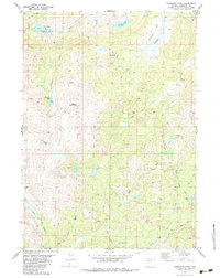
1981 Map of Washakie Park
USGS Topo · Published 1984About this map
The high-altitude drainage basins of the Little Wind River and its various forks define this portion of the Wind River Indian Reservation in the mid-1970s. Dominated by prominent peaks such as Mount Shoshone and Mount Baldy, the landscape is etched with a network of traditional routes, including the Pack Trail and the Gaylord Lake Trail. These pathways connect remote alpine water bodies like Shoshone Lake, Yahtic Lake, and Marys Lake, illustrating the logistical importance of pack animal travel in this wilderness during the era. The presence of Tepee Pass and the open meadows of Washakie Park suggests a land used primarily for transit and high-country grazing. From the South Fork Little Wind River to the headwaters of Moss Creek, the map details a complex hydrology where streams like Lost Creek and Roost Creek flow through steep glacial topography.
Find a feature on this map
22 named features on this map. Tap any name to fly to it.
Don’t see what you’re looking for? This feature index may not catch every label — zoom into the map to look around manually.
Map Details
Editions of this 1981 Washakie Park Map
This is the sole edition of this map. No revisions or reprints were ever made.
Other maps of this area

1937 · Moccasin Lake
USGS Topo · 1:48,000

1938 · Mt Bonneville
USGS Topo · 1:62,500

1941 · Mt Bonneville
USGS Topo · 1:62,500

1942 · Mt Bonneville
USGS Topo · 1:62,500

1943 · Moccasin Lake
USGS Topo · 1:62,500

1952 · Wise Flat
USGS Topo · 1:24,000

1952 · Paradise Basin
USGS Topo · 1:24,000

1952 · St. Lawrence Basin
USGS Topo · 1:24,000

1955 · Thermopolis
USGS Topo · 1:250,000

1955 · Lander
USGS Topo · 1:250,000