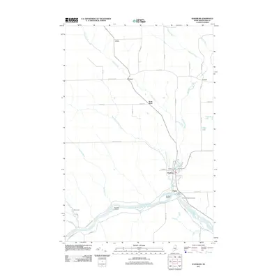
2011 Map of Washburn
USGS Topo · Published 2011About this map
Washburn and its surrounding Aroostook County landscapes are defined here by the winding Aroostook River and the agricultural infrastructure that supports the region's potato-growing legacy. The presence of Potato Siding near the center of town underscores the historical importance of rail transport for local harvests. The river itself is anchored by the Washburn Dam and flows past Stratton Island and Donnelly Island, while the smaller Salmon Brook and its branches drain the northern acreage toward the settlements of Perham and North Wade. Genealogists and local historians can locate several resting places, including Fairview Cemetery in the north and the Riverside Cemetery complex near Bugbee in the south. The map also reveals rural community points like Carson and the isolated Wilder Camp, reflecting a landscape deeply tied to the land and its seasonal rhythms.
Find a feature on this map
49 named features on this map. Tap any name to fly to it.
Don’t see what you’re looking for? This feature index may not catch every label — zoom into the map to look around manually.
Map Details
Editions of this 2011 Washburn Map
This is the sole edition of this map. No revisions or reprints were ever made.
Other maps of this area

1929 · Portage
USGS Topo · 1:62,500

1929 · Caribou
USGS Topo · 1:48,000

1931 · Ashland
USGS Topo · 1:48,000

1931 · Portage
USGS Topo · 1:62,500

1932 · Caribou
USGS Topo · 1:62,500

1934 · Ashland
USGS Topo · 1:62,500

1935 · Presque Isle
USGS Topo · 1:62,500

1953 · Ashland
USGS Topo · 1:62,500

1953 · Portage
USGS Topo · 1:62,500
1953 · New Sweden
USGS Topo · 1:24,000