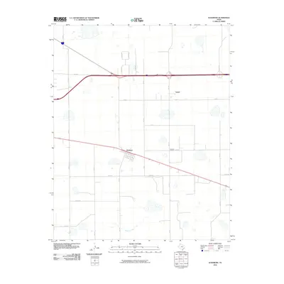
2010 Map of Washburn
USGS Topo · Published 2010About this map
Washburn and Yarnall anchor this portion of the Texas Panhandle, where the high plains transition into the drainages of the Mulberry Creek basin. The map reveals a strict rectilinear grid of county roads typical of the region's agricultural layout, with names like Bravo Rd, Charlie Rd, Delta Rd, and Alpha Rd marking the surveyed landscape. The community of Washburn is depicted with its local street grid, while the Washburn Cemetery serves as a significant genealogical landmark for the surrounding Armstrong County area. Transportation is central to the area's geography, shown through the intersection of state-maintained farm-to-market roads like FM 2575, FM 2250, and FM 2373, which facilitate the movement of goods across this sparsely populated ranching and farming territory.
Find a feature on this map
24 named features on this map. Tap any name to fly to it.
Don’t see what you’re looking for? This feature index may not catch every label — zoom into the map to look around manually.
Map Details
Editions of this 2010 Washburn Map
This is the sole edition of this map. No revisions or reprints were ever made.
Other maps of this area

1953 · Mayer
USGS Topo · 1:24,000

1953 · Sevenmile Basin
USGS Topo · 1:24,000

1954 · Amarillo
USGS Topo · 1:250,000

1956 · Washburn
USGS Topo · 1:24,000

1956 · Thomas Ranch
USGS Topo · 1:24,000

1956 · Pullman
USGS Topo · 1:24,000

1958 · Amarillo
USGS Topo · 1:250,000

1960 · Fairview
USGS Topo · 1:24,000

1960 · Claude
USGS Topo · 1:62,500

1966 · Panhandle West
USGS Topo · 1:24,000