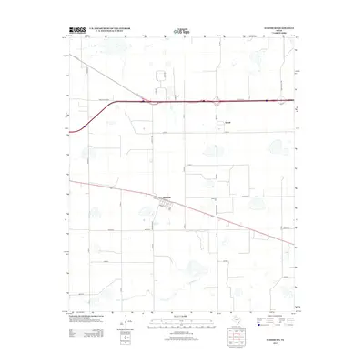
2012 Map of Washburn
USGS Topo · Published 2012About this map
Washburn and Yarnall anchor this portion of the Texas Panhandle, where the high plains are segmented by an orderly grid of country roads and modern transportation corridors. The settlement of Washburn displays a clear street plan featuring Lively St, Moore St, and White, situated just south of the major highway junction. To the east, the Washburn Cem serves as a significant local landmark for genealogical research. The landscape is defined by its agricultural layout, with long thoroughfares like Durrett Rd and Ranch Road 2373 crossing the territory. In the southern reaches, the natural drainage of Mulberry Cr meanders through the terrain, providing a rare break in the geometric precision of the surveyed sections. This map documents the area during a period of established highway connectivity, showing the relationship between the Interstate 40 corridor and the older town sites that preceded it.
Find a feature on this map
33 named features on this map. Tap any name to fly to it.
Don’t see what you’re looking for? This feature index may not catch every label — zoom into the map to look around manually.
Map Details
Editions of this 2012 Washburn Map
This is the sole edition of this map. No revisions or reprints were ever made.
Other maps of this area

1953 · Mayer
USGS Topo · 1:24,000

1953 · Sevenmile Basin
USGS Topo · 1:24,000

1954 · Amarillo
USGS Topo · 1:250,000

1956 · Washburn
USGS Topo · 1:24,000

1956 · Thomas Ranch
USGS Topo · 1:24,000

1956 · Pullman
USGS Topo · 1:24,000

1958 · Amarillo
USGS Topo · 1:250,000

1960 · Fairview
USGS Topo · 1:24,000

1960 · Claude
USGS Topo · 1:62,500

1966 · Panhandle West
USGS Topo · 1:24,000