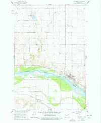
1961 Map of Washburn
USGS Topo · Published 1978About this map
The Missouri River forms the central artery of this landscape, dividing McLean and Oliver counties during the early 1960s. The town of Washburn sits on the northern bank, serving as a hub for both the Soo Line and the historic Lewis and Clark Trail. To the south, across the water, the Northern Pacific railroad services the community of Hensler.
Find a feature on this map
19 named features on this map. Tap any name to fly to it.
Don’t see what you’re looking for? This feature index may not catch every label — zoom into the map to look around manually.
Map Details
Editions of this 1961 Washburn Map
3 editions found
Other maps of this area

1949 · Turtle Creek
USGS Topo · 1:62,500

1949 · Washburn
USGS Topo · 1:62,500

1950 · Wilton
USGS Topo · 1:62,500

1954 · McClusky
USGS Topo · 1:250,000

1958 · McClusky
USGS Topo · 1:250,000

1961 · Turtle Creek SW
USGS Topo · 1:24,000

1961 · Washburn
USGS Topo · 1:24,000

1961 · Washburn NE
USGS Topo · 1:24,000

1961 · Turtle Creek NW
USGS Topo · 1:24,000

1961 · Underwood
USGS Topo · 1:24,000