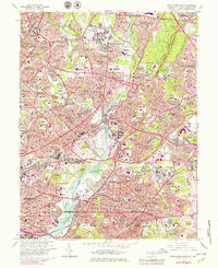
1965 Map of Washington East
USGS Topo · Published 1979About this map
The Anacostia River serves as the central artery for this densely settled corridor, where the urban grid of Washington meets the evolving suburbs of Maryland. The landscape is defined by its deep historical institutional footprint, featuring the extensive National Arboretum, Gallaudet College, and the Kenilworth Aquatic Gardens. Along the river's eastern banks, the map captures a period of significant mid-century infrastructure, with the Baltimore Washington Parkway and Conrail lines carving through established neighborhoods like Ivy City and Trinidad. Notable for genealogists are the large burial grounds such as Fort Lincoln Cemetery and Mt Olivet Cemetery. Cultural landmarks range from the Marine Barracks near the Stadium to religious and educational hubs like St Josephs Seminary and Providence Hospital. The northern reaches include the academic and residential growth around College Park and Takoma Park, reflecting the region's mid-to-late 20th-century expansion.
Find a feature on this map
243 named features on this map. Tap any name to fly to it.
Don’t see what you’re looking for? This feature index may not catch every label — zoom into the map to look around manually.
Map Details
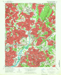
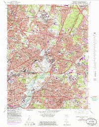
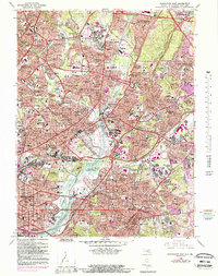
Editions of this 1965 Washington East Map
5 editions found

Other maps of this area

1890 · Mt. Vernon
USGS Topo · 1:125,000

1891 · Mt. Vernon
USGS Topo · 1:125,000

1892 · Laurel
USGS Topo · 1:62,500

1893 · Frederick
USGS Topo · 1:125,000

1894 · Laurel
USGS Topo · 1:62,500

1894 · Frederick
USGS Topo · 1:125,000

1894 · Mt. Vernon
USGS Topo · 1:125,000

1897 · Laurel
USGS Topo · 1:62,500

1897 · Mt. Vernon
USGS Topo · 1:125,000

1899 · Patuxent
USGS Topo · 1:125,000