1965 Map of Washington East
USGS Topo · Published 1988About this map
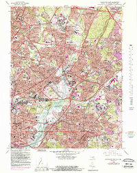
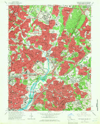
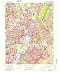
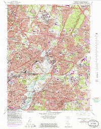
The Anacostia River serves as the central artery for this 1965 survey, which traces the transition from the District of Columbia into the growing suburbs of Prince George's County. The landscape is dominated by significant institutional and recreational spaces, from the sprawling campus of the University of Maryland and Byrd Stadium in the north to the National Arboretum and Kenilworth Aquatic Gardens along the riverbanks. This period shows a densely woven network of parkways and residential developments, including the established communities of Hyattsville, College Park, and Cheverly. Along the waterfront, the map captures industrial and military history at the Washington Navy Yard and the Marine Barracks, while inland, numerous spiritual and educational sites like St Josephs Sem and St Pauls College reflect the area's rich social fabric. Large memorial grounds like Fort Lincoln Cemetery and the Congressional Cemetery anchor the geography of the eastern District line.
Find a feature on this map
196 named features on this map. Tap any name to fly to it.
Don’t see what you’re looking for? This feature index may not catch every label — zoom into the map to look around manually.
Map Details
Editions of this 1965 Washington East Map
5 editions found

Other maps of this area

1890 · Mt. Vernon
USGS Topo · 1:125,000

1891 · Mt. Vernon
USGS Topo · 1:125,000

1892 · Laurel
USGS Topo · 1:62,500

1893 · Frederick
USGS Topo · 1:125,000

1894 · Laurel
USGS Topo · 1:62,500

1894 · Frederick
USGS Topo · 1:125,000

1894 · Mt. Vernon
USGS Topo · 1:125,000

1897 · Laurel
USGS Topo · 1:62,500

1897 · Mt. Vernon
USGS Topo · 1:125,000

1899 · Patuxent
USGS Topo · 1:125,000