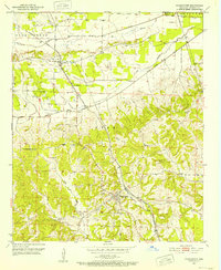
1951 Map of Washington
USGS Topo · Published 1952About this map
The settlement of Washington anchors the southern half of this mid-century Arkansas survey, characterized by a transition from the rolling hills of the southwest into the alluvial plains of the Ozan area. The Missouri Pacific railroad cuts through the landscape, serving as a primary transit corridor between the town of Ozan and the outlying farmsteads. This era reveals a community deeply connected by rural institutions, with local landmarks like St Marks Ch, Mt Moriah Home Ch, and the St Peter Cem providing essential touchstones for genealogical research.
Find a feature on this map
20 named features on this map. Tap any name to fly to it.
Don’t see what you’re looking for? This feature index may not catch every label — zoom into the map to look around manually.
Map Details
Editions of this 1951 Washington Map
2 editions found
Other maps of this area

1951 · Blevins
USGS Topo · 1:24,000

1951 · Columbus
USGS Topo · 1:24,000

1951 · Sheppard
USGS Topo · 1:24,000

1951 · Nashville
USGS Topo · 1:24,000

1951 · Washington
USGS Topo · 1:24,000

1951 · Pisgah
USGS Topo · 1:24,000

1951 · Hope
USGS Topo · 1:24,000

1951 · Mc Nab
USGS Topo · 1:24,000

1951 · McCaskill
USGS Topo · 1:24,000

1953 · El Dorado
USGS Topo · 1:250,000