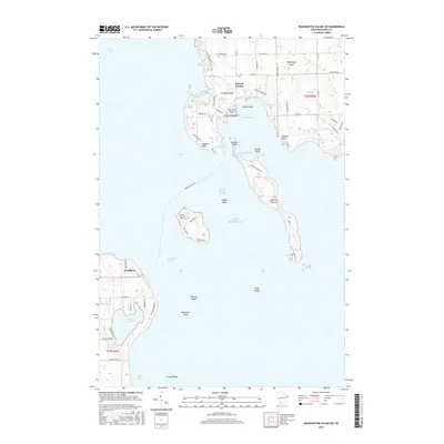
2016 Map of Washington Island SW
USGS Topo · Published 2016About this map
Detroit Harbor and the southern reaches of Washington Island anchor this coastal study of the dangerous waters where Green Bay meets Lake Michigan. The map details the intricate shoreline of the Porte des Morts passage, a maritime gateway flanked by Plum Island and Detroit Island. On the mainland at the Door Peninsula tip, the settlement of Northport stands near the secluded Europe Lake and Europe Bay. Nautical features including Middle Shoal, Waverly Shoal, and the lonely Pilot Island underscore the area's maritime hazards. Land use is characterized by a network of island roads such as Michigan Rd and Detroit Harbor Rd connecting local points like Gislason Beach and Richters Point, reflecting the settled character of this isolated island community.
Find a feature on this map
58 named features on this map. Tap any name to fly to it.
Don’t see what you’re looking for? This feature index may not catch every label — zoom into the map to look around manually.
Map Details
Editions of this 2016 Washington Island SW Map
This is the sole edition of this map. No revisions or reprints were ever made.
Other maps of this area

1954 · Escanaba
USGS Topo · 1:250,000

1957 · Escanaba
USGS Topo · 1:250,000

1958 · Escanaba
USGS Topo · 1:250,000

1960 · Washington Island
USGS Topo · 1:62,500

1960 · Sister Bay
USGS Topo · 1:62,500

1960 · Ellison Bay
USGS Topo · 1:62,500

1981 · Marinette
USGS Topo · 1:100,000

1982 · Washington Island SE
USGS Topo · 1:24,000

1982 · Washington Island NW
USGS Topo · 1:24,000
1982 · Ellison Bay
USGS Topo · 1:24,000