
1982 Map of Washington Island NW
USGS Topo · Published 1982About this map
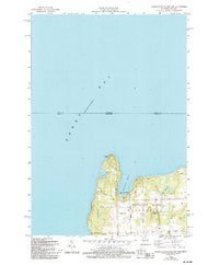
Boyer Bluff anchors the northern reaches of the Washington Island community in the early 1980s, marking a rugged point where the waters of Green Bay meet Washington Harbor. This coastal landscape is defined by its maritime and agricultural character, with a network of corridors including McDonald Road and Rangeline Road connecting inland farms to the shore. The interior reveals a quiet community life centered around places of worship such as Bethel Ch, St Michaels Chapel, and Trinity Ch. Nearby, the presence of the Township Cem and the Washington Island Landing Field indicates a self-sufficient island economy. Natural features like the sheltered Little Lake and the low-lying Coffee Swamp illustrate the diverse environmental pocketing found at this latitude of Lake Michigan, while the Lookout Tower suggests a high point for observation and navigation.
Find a feature on this map
24 named features on this map. Tap any name to fly to it.
Don’t see what you’re looking for? This feature index may not catch every label — zoom into the map to look around manually.
Map Details
Editions of this 1982 Washington Island NW Map
2 editions found
Other maps of this area

1954 · Escanaba
USGS Topo · 1:250,000

1957 · Escanaba
USGS Topo · 1:250,000

1958 · Escanaba
USGS Topo · 1:250,000

1958 · Escanaba
USGS Topo · 1:62,500

1958 · Peninsula Point
USGS Topo · 1:62,500

1960 · Washington Island
USGS Topo · 1:62,500

1960 · Ellison Bay
USGS Topo · 1:62,500

1981 · Marinette
USGS Topo · 1:100,000

1982 · Washington Island SE
USGS Topo · 1:24,000

1982 · Escanaba
USGS Topo · 1:100,000