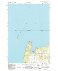
1982 Map of Washington Island NW
USGS Topo · Published 1994About this map
Washington Island stands as a prominent maritime landmark at the northern tip of Door County, where the waters of Green Bay meet the Michigan state line. This 1982 survey reveals a landscape shaped by both its glacial past and its isolation in the Great Lakes. The northern shoreline is defined by the steep elevation of Bowyer Bluff and the sheltered waters of Washington Harbor. Inward from the coast, the island’s community structure is anchored by several places of worship, including Bethel Ch, St Michaels Chapel, and Trinity Ch, as well as the Township Cem.
Find a feature on this map
22 named features on this map. Tap any name to fly to it.
Don’t see what you’re looking for? This feature index may not catch every label — zoom into the map to look around manually.
Map Details
Editions of this 1982 Washington Island NW Map
2 editions found
Other maps of this area

1954 · Escanaba
USGS Topo · 1:250,000

1957 · Escanaba
USGS Topo · 1:250,000

1958 · Escanaba
USGS Topo · 1:250,000

1958 · Escanaba
USGS Topo · 1:62,500

1958 · Peninsula Point
USGS Topo · 1:62,500

1960 · Washington Island
USGS Topo · 1:62,500

1960 · Ellison Bay
USGS Topo · 1:62,500

1981 · Marinette
USGS Topo · 1:100,000

1982 · Washington Island SE
USGS Topo · 1:24,000

1982 · Washington Island NW
USGS Topo · 1:24,000