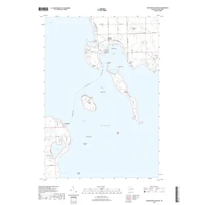
2018 Map of Washington Island SW
USGS Topo · Published 2018About this map
Detroit Harbor serves as a primary maritime gateway on the southern end of Washington Island, where the local road network converges near the protected waters of Figenscaus Harbor and West Harbor. The landscape is defined by the complex archipelago and treacherous shoals of the Porte des Morts passage, a historic transit point between Green Bay and Lake Michigan. To the south, Detroit Island and Plum Island dominate the waterway, the latter featuring the Eagle View Coastal Loop and Green Bay Trail. On the mainland peninsula, the settlement of Northport marks the terminus for travelers heading toward the island, situated just north of the inland Europe Lake. This survey illustrates the intricate relationship between the Door County coast and its outlying islands, from the small Big Susie Island to the isolated Pilot Island and Gravel Island further offshore.
Find a feature on this map
61 named features on this map. Tap any name to fly to it.
Don’t see what you’re looking for? This feature index may not catch every label — zoom into the map to look around manually.
Map Details
Editions of this 2018 Washington Island SW Map
This is the sole edition of this map. No revisions or reprints were ever made.
Other maps of this area

1954 · Escanaba
USGS Topo · 1:250,000

1957 · Escanaba
USGS Topo · 1:250,000

1958 · Escanaba
USGS Topo · 1:250,000

1960 · Washington Island
USGS Topo · 1:62,500

1960 · Sister Bay
USGS Topo · 1:62,500

1960 · Ellison Bay
USGS Topo · 1:62,500

1981 · Marinette
USGS Topo · 1:100,000

1982 · Washington Island SE
USGS Topo · 1:24,000

1982 · Washington Island NW
USGS Topo · 1:24,000
1982 · Ellison Bay
USGS Topo · 1:24,000