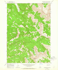
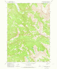
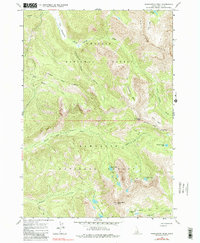
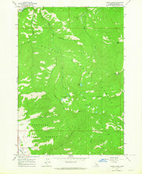
1964 Map of Washington Peak
USGS Topo · Published 1966About this map
Challis National Forest and Sawtooth National Forest meet in this high-elevation corner of Custer County, Idaho, documented through 1964 field checks. The landscape is defined by the sharp elevations of the White Cloud Peaks and the prominence of Washington Peak. The map records a legacy of resource extraction at high altitudes, notably at the Aztec Mine near Fisher Creek and the Black Rock Mine situated in Washington Basin.
Find a feature on this map
28 named features on this map. Tap any name to fly to it.
Don’t see what you’re looking for? This feature index may not catch every label — zoom into the map to look around manually.
Map Details
Editions of this 1964 Washington Peak Map
3 editions found
Other maps of this area

1900 · Sawtooth
USGS Topo · 1:125,000

1919 · Custer
USGS Topo · 1:125,000

1922 · Custer
USGS Topo · 1:125,000

1955 · Hailey
USGS Topo · 1:250,000

1957 · Challis
USGS Topo · 1:250,000

1959 · Hailey
USGS Topo · 1:250,000

1960 · Challis
USGS Topo · 1:250,000

1962 · Hailey
USGS Topo · 1:250,000

1963 · Challis
USGS Topo · 1:250,000
1963 · Casino Lakes
USGS Topo · 1:24,000