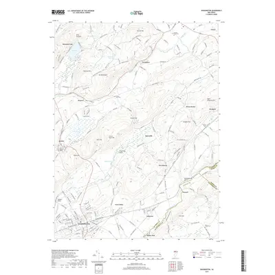
2019 Map of Washington
USGS Topo · Published 2019About this map
The Morris Canal Trl preserves a historic transport corridor through this corner of Warren County, reflecting the industrial heritage of the Pohatcong Valley and Musconetcong Valley. In the borough of Washington, a dense street grid fans out from the rail lines, while smaller hamlets like Port Colden and Port Murray signal the area's historical reliance on the canal system. The terrain is defined by prominent northeast-southwest ridges, including Jenny Jump Mtn and Oxford Mtn, which create natural barriers between the drainage basins of the Pequest River and the Pohatcong Creek. This layout illustrates a classic New Jersey Highlands settlement pattern where development is concentrated in the fertile valleys between steep, wooded heights like Baldpate Mtn and Mt Mohepinoke. For the local historian, the map identifies several significant burial sites, including Pequest Union Cem and the County Home Cem located near Stewart Gap.
Find a feature on this map
174 named features on this map. Tap any name to fly to it.
Don’t see what you’re looking for? This feature index may not catch every label — zoom into the map to look around manually.
Map Details
Editions of this 2019 Washington Map
This is the sole edition of this map. No revisions or reprints were ever made.
Other maps of this area

1888 · Hackettstown
USGS Topo · 1:62,500

1890 · Easton
USGS Topo · 1:62,500

1890 · High Bridge
USGS Topo · 1:62,500

1891 · Easton
USGS Topo · 1:62,500

1891 · Delaware Water Gap
USGS Topo · 1:62,500

1893 · Delaware Water Gap
USGS Topo · 1:62,500

1894 · Hackettstown
USGS Topo · 1:62,500

1898 · Hackettstown
USGS Topo · 1:62,500

1898 · High Bridge
USGS Topo · 1:62,500

1900 · Raritan
USGS Topo · 1:125,000
Featured Places
- Washington, NJ
- Oxford Township, NJ
- Hope Township, NJ
- Port Murray, Mansfield Township
- Washington Township, NJ