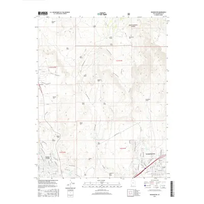
2017 Map of Washington
USGS Topo · Published 2017About this map
The Washington area and its transition into the high desert are documented in this 2017 survey, where suburban development meets the ancient geology of the Mojave Desert. The map reveals the expansion of Santa Clara and Washington, showing how modern residential streets like Buena Vista Blvd and Concord Pkwy now border the rugged Middleton Black Ridge. For historians, the sheet preserves the location of the Old Alexander Cem and the Washington City Cem, markers of the region's earlier settlement.
Find a feature on this map
69 named features on this map. Tap any name to fly to it.
Don’t see what you’re looking for? This feature index may not catch every label — zoom into the map to look around manually.
Map Details
Editions of this 2017 Washington Map
This is the sole edition of this map. No revisions or reprints were ever made.
Other maps of this area

1885 · St. George
USGS Topo · 1:250,000

1891 · St. George
USGS Topo · 1:250,000

1953 · Cedar City
USGS Topo · 1:250,000

1954 · La Verkin 3 NW
USGS Topo · 1:24,000

1954 · La Verkin 3 SW
USGS Topo · 1:24,000

1954 · St. George
USGS Topo · 1:62,500

1954 · Hurricane
USGS Topo · 1:62,500
1956 · St. George SE
USGS Topo · 1:24,000

1956 · St. George NW
USGS Topo · 1:24,000

1956 · St. George NE
USGS Topo · 1:24,000