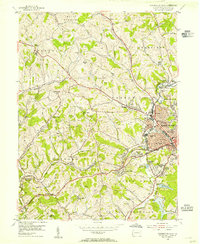
1954 Map of Washington West
USGS Topo · Published 1955About this map
The city of Washington serves as the focal point of this 1954 mid-century survey, revealing a dense network of institutional and industrial infrastructure. The eastern edge of the map captures the urban growth of Tylerdale, Elwood Park, and Gabby Heights, while the Baltimore and Ohio and Pennsylvania railroads snake through the landscape, supporting operations like the Arden Mines. The surrounding townships, including Canton, Buffalo, and North Franklin, are dotted with numerous small educational and religious sites such as the Buffalo Grange Cleland Sch and Crossroads Ch.
Find a feature on this map
68 named features on this map. Tap any name to fly to it.
Don’t see what you’re looking for? This feature index may not catch every label — zoom into the map to look around manually.
Map Details
Editions of this 1954 Washington West Map
3 editions found
Other maps of this area

1901 · Amity
USGS Topo · 1:62,500

1904 · Amity
USGS Topo · 1:62,500

1904 · Carnegie
USGS Topo · 1:62,500

1904 · Burgettstown
USGS Topo · 1:62,500

1906 · Burgettstown
USGS Topo · 1:62,500

1906 · Carnegie
USGS Topo · 1:62,500

1907 · Claysville
USGS Topo · 1:62,500

1908 · Carnegie
USGS Topo · 1:62,500

1951 · Canton
USGS Topo · 1:250,000

1953 · Canton
USGS Topo · 1:250,000
Featured Places
- Washington, PA
- South Strabane Township, PA
- Buffalo, Hopewell Township
- Chartiers Township, PA
- Wolfdale, Canton Township