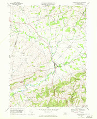
1969 Map of Washingtonville
USGS Topo · Published 1972About this map
Washingtonville serves as the central hub of this agricultural landscape, where the waters of Chillisquaque Creek and Mud Creek converge. The terrain is defined by the prominent Limestone Ridge and the broad Liberty Valley to the south, reflecting a settlement pattern deeply tied to the limestone-rich soil and valley floors. Throughout the late 1960s, this region maintained a dense network of local institutions, including the DeLong Memorial Sch and numerous country churches like Hendrickson Ch and St James Ch. A Covered Bridge spans the creek south of town, a surviving piece of traditional infrastructure alongside the modern utility of a Radio Facility and a local Landing Strip. Small hamlets such as Strawberry Ridge, Exchange, and Limestoneville dot the map, many situated at crossroad junctions or along the Penn Central rail line.
Find a feature on this map
47 named features on this map. Tap any name to fly to it.
Don’t see what you’re looking for? This feature index may not catch every label — zoom into the map to look around manually.
Map Details
Editions of this 1969 Washingtonville Map
4 editions found
Other maps of this area

1892 · Shamokin
USGS Topo · 1:62,500

1893 · Sunbury
USGS Topo · 1:62,500

1893 · Shamokin
USGS Topo · 1:62,500

1924 · Milton
USGS Topo · 1:62,500

1935 · Hughesville
USGS Topo · 1:62,500

1943 · Shamokin
USGS Topo · 1:62,500

1943 · Sunbury
USGS Topo · 1:62,500

1950 · Harrisburg
USGS Topo · 1:250,000

1952 · Shamokin
USGS Topo · 1:62,500

1953 · Hughesville
USGS Topo · 1:62,500
Featured Places
- Washingtonville, PA
- Lewis Township, PA
- Turbot Township, PA
- Schuyler, Lewis Township
- Limestoneville, Limestone Township