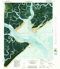
1978 Map of Wassaw Sound
USGS Topo · Published 1978About this map
Fort Pulaski National Monument stands at the northern edge of this coastal environment, guarding the entrance to the Savannah area waterways. This orthophotomap provides a hybrid view of the Georgia coast in the late 1970s, combining traditional topographic contouring with aerial imagery to reveal the complex network of salt marshes and tidal channels. Large barrier landmasses like Wassaw Island and Little Tybee Island are characterized by dense maritime vegetation and shifting sandy points, including Cape Charlotte and Cape May. The intricate drainage system is dominated by the Wilmington River and Bull River, which frame Wilmington Island. For the historian, the map documents the protected lands of the Wassaw National Wildlife Refuge and the topographical nuances of the Atlantic shoreline, where labels like Area subject to frequent change and Salt Pond Shoal indicate the dynamic nature of the Georgia bight.
Find a feature on this map
48 named features on this map. Tap any name to fly to it.
Don’t see what you’re looking for? This feature index may not catch every label — zoom into the map to look around manually.
Map Details
Editions of this 1978 Wassaw Sound Map
This is the sole edition of this map. No revisions or reprints were ever made.
Other maps of this area

1920 · Wassaw Sound
USGS Topo · 1:62,500

1920 · Bluffton
USGS Topo · 1:62,500

1942 · Savannah
USGS Topo · 1:62,500

1944 · Ossabaw Island
USGS Topo · 1:62,500

1945 · Bluffton
USGS Topo · 1:62,500

1945 · Ossabaw Island
USGS Topo · 1:62,500

1945 · Wassaw Sound
USGS Topo · 1:62,500

1946 · Brunswick
USGS Topo · 1:250,000

1947 · Savannah
USGS Topo · 1:250,000

1948 · Brunswick
USGS Topo · 1:250,000