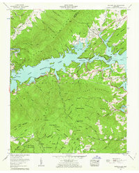
1960 Map of Watauga Dam
USGS Topo · Published 1962About this map
Watauga Lake dominates the center of this landscape, its expansive waters held by the Watauga Dam and infrastructure including a power intake tower and overflow spillway. The settlement of Butler stands at the northern reaches of the reservoir, connected by the Butler Memorial Bridge near the junction of Cobb Creek and the Watauga River. This survey captures the region after the significant hydrological changes brought by the Tennessee Valley Authority, showing the relocated communities and established recreation points like Lakeshore Dock and Watauga Point Recreational Area.
Find a feature on this map
118 named features on this map. Tap any name to fly to it.
Don’t see what you’re looking for? This feature index may not catch every label — zoom into the map to look around manually.
Map Details
Editions of this 1960 Watauga Dam Map
4 editions found
Other maps of this area

1891 · Roan Mountain
USGS Topo · 1:125,000

1893 · Cranberry
USGS Topo · 1:125,000

1894 · Roan Mountain
USGS Topo · 1:125,000

1895 · Cranberry
USGS Topo · 1:125,000

1899 · Cranberry
USGS Topo · 1:125,000

1902 · Cranberry
USGS Topo · 1:125,000

1904 · Roan Mountain
USGS Topo · 1:125,000

1934 · White Rocks Mtn
USGS Topo · 1:24,000

1934 · Iron Mtn Gap
USGS Topo · 1:24,000

1934 · Elk Park
USGS Topo · 1:24,000