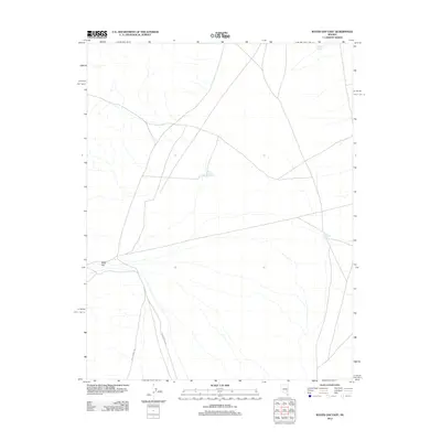
2012 Map of Water Gap East
USGS Topo · Published 2012About this map
Triangle Spring and scattered water catchments define this arid landscape within Nye County, Nevada, as documented by the U.S. Geological Survey in 2012. The area is characterized by a sparse network of roads and tracks that navigate the basin floor, likely serving grazing and land management needs in this dry terrain. Critical water sources for local ranching or wildlife are noted by features such as Sheep Reservoir Number 1 and Line Reservoir, which highlight the importance of managed water collection in a region defined by its lack of permanent flowing streams. This study provides a precise record of the topography and infrastructure in the high desert shortly after the turn of the twenty-first century.
Find a feature on this map
3 named features on this map. Tap any name to fly to it.
Don’t see what you’re looking for? This feature index may not catch every label — zoom into the map to look around manually.
Map Details
Editions of this 2012 Water Gap East Map
This is the sole edition of this map. No revisions or reprints were ever made.
Other maps of this area

1954 · Caliente
USGS Topo · 1:250,000

1956 · Lund
USGS Topo · 1:250,000

1959 · Caliente
USGS Topo · 1:250,000

1960 · Lund
USGS Topo · 1:250,000

1970 · Oreana Spring
USGS Topo · 1:24,000
1971 · Timber Mtn Pass NW
USGS Topo · 1:24,000
1971 · Timber Mtn Pass West
USGS Topo · 1:24,000

1985 · Water Gap East
USGS Topo · 1:24,000

1985 · Coal Valley Reservoir
USGS Topo · 1:24,000

1985 · Murphy Gap NW
USGS Topo · 1:24,000