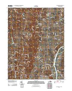
2011 Map of Waterford
USGS Topo · Published 2011About this map
The Potomac River forms the eastern boundary of this Loudoun County landscape, where historical river crossings and Civil War landmarks converge near Leesburg. Along the riverbanks, the Balls Bluff Battlefield and the Balls Bluff National Cemetery stand as significant memorials to the region's 19th-century military history. Further north, Whites Ferry remains a visible link across the water toward Harrison Island and Maryland.
Find a feature on this map
125 named features on this map. Tap any name to fly to it.
Don’t see what you’re looking for? This feature index may not catch every label — zoom into the map to look around manually.
Map Details
Editions of this 2011 Waterford Map
This is the sole edition of this map. No revisions or reprints were ever made.
Other maps of this area

1884 · Harpers Ferry
USGS Topo · 1:125,000

1891 · Harpers Ferry
USGS Topo · 1:125,000

1893 · Frederick
USGS Topo · 1:125,000

1893 · Harpers Ferry
USGS Topo · 1:125,000

1894 · Frederick
USGS Topo · 1:125,000

1908 · Middletown
USGS Topo · 1:48,000
1908 · Seneca
USGS Topo · 1:62,500

1908 · Ijamsville
USGS Topo · 1:62,500

1909 · Ijamsville
USGS Topo · 1:62,500

1910 · Antietam
USGS Topo · 1:62,500