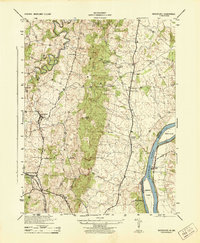
1944 Map of Waterford
USGS Topo · Published 1944About this map
Catoctin Mountain bisects this landscape of Northern Virginia during the mid-1940s, creating a natural barrier between the agricultural valley of Waterford and the Potomac River corridor. The village of Waterford appears as a primary focal point, while the eastern boundary is defined by the river and the Chesapeake and Ohio Canal (Abandoned), which traces the Maryland border. This survey captures a moment when the Washington and Old Dominion railroad still served the region, providing vital transit to Paeonian Springs and Clarks Gap.
Find a feature on this map
35 named features on this map. Tap any name to fly to it.
Don’t see what you’re looking for? This feature index may not catch every label — zoom into the map to look around manually.
Map Details
Editions of this 1944 Waterford Map
This is the sole edition of this map. No revisions or reprints were ever made.
Other maps of this area

1884 · Harpers Ferry
USGS Topo · 1:125,000

1891 · Harpers Ferry
USGS Topo · 1:125,000

1893 · Frederick
USGS Topo · 1:125,000

1893 · Harpers Ferry
USGS Topo · 1:125,000

1894 · Frederick
USGS Topo · 1:125,000

1908 · Middletown
USGS Topo · 1:48,000

1908 · Seneca
USGS Topo · 1:62,500

1908 · Ijamsville
USGS Topo · 1:62,500

1909 · Ijamsville
USGS Topo · 1:62,500

1910 · Antietam
USGS Topo · 1:62,500